About Us

❑ World weather watch meteorological satellite network
Working together in Weather, Climate and Water
Get the most up to date weather information for your location - no matter where you are.
Weather forecasts for all districts around United States
In Weather Tomorrow not only gives you the basic weather information, but we also aim to tell you more about what the weather is doing, has done, and is expected to do. American forecasts, detailed storm forecasts, weather station network observations, and the Bureau's RADAR imagery are all localised for your town.
World Meteorological Organization
The World Meteorological Organization (WMO) coordinates global scientific activities related to weather prediction, air pollution research, climate change, ozone layer depletion studies, and tropical storm forecasting. These efforts lead to more timely and accurate weather information and services for various sectors, including public, private, and commercial use such as international airline and shipping industries. WMO's work contributes to safeguarding life and property, supporting socio-economic development, and protecting the environment.
As a 185-Member Organization based in Geneva within the United Nations, WMO serves as the authoritative scientific voice on Earth's atmosphere and climate. It was established through the World Meteorological Convention adopted at the Twelfth Conference of Directors of the International Meteorological Organization (IMO) in 1947. Although the Convention became effective in 1950, WMO started operating as IMO's successor in 1951 and was later designated as a specialized agency of the United Nations.
WMO's objectives include facilitating international cooperation in establishing networks of meteorological and hydrological observation stations, promoting rapid exchange and standardization of meteorological data, and encouraging the application of meteorology in various sectors like aviation, shipping, agriculture, and water management. Additionally, WMO supports operational hydrology, fosters research, and provides training in meteorology.

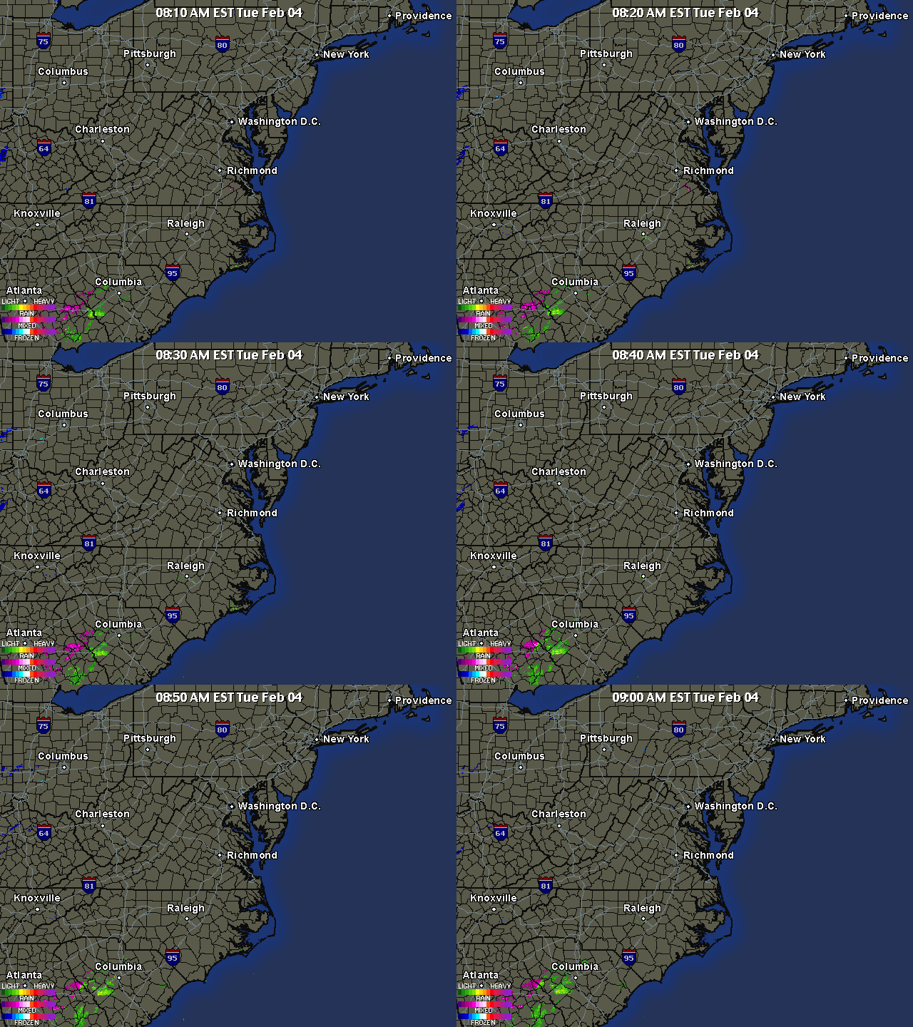
❑ Regional Animated Radar
Organization
The World Meteorological Congress, WMO's highest authority, convenes every four years to set policies, endorse programs and budgets, and enact regulations.
The Executive Council, comprising thirty-six members including the President and three Vice-Presidents, convenes at least annually. Its responsibilities include preparing studies and recommendations for the Congress, overseeing the implementation of Congress decisions and regulations, and providing technical guidance to Members.
Members are organized into six regional associations (Africa, Asia, South America, North and Central America, South-West Pacific, and Europe). These associations meet every four years to coordinate meteorological and operational hydrological activities within their respective regions and address issues referred by the Council.
WMO operates through eight technical commissions: aeronautical meteorology; agricultural meteorology; atmospheric sciences; basic systems; climatology; hydrology; instruments and observation methods; and marine meteorology. Each commission convenes every four years.
The Secretariat
The Secretariat, led by the Secretary-General, acts as the administrative, documentation, and information hub of the Organization. It is responsible for preparing, editing, producing, and disseminating the Organization's publications, fulfilling the duties outlined in the Convention and other foundational documents, and providing secretariat assistance to WMO's constituent bodies as mentioned earlier. The current Secretary-General of WMO is Prof. G.O.P. Obasi from Nigeria.
World Weather Watch
WMO's primary scientific and technical initiatives encompass the World Weather Watch (WWW), which forms the core of WMO's operations. The WWW delivers real-time global weather data through Member-operated observation networks and communication links with nine satellites (four polar-orbiting and five geostationary), around 10,000 land-based observation stations, 7,000 ship stations, and 300 moored and drifting buoys equipped with automated weather stations.
Every day, over 15 million data characters and 2,000 weather charts are transmitted via high-speed links to three World, 35 Regional, and 183 National Meteorological Centers. These centers collaborate to produce weather analyses and forecasts using sophisticated methods, benefiting transoceanic ships, aircraft, research initiatives on air pollution and global climate change, media outlets, and the general public. WMO establishes international agreements on standards, codes, measurements, and communications, crucial for ensuring seamless data exchange and availability.
The availability of global data is crucial for weather forecasting; without WMO, nations would need to negotiate individual agreements to meet their national weather service requirements, impacting sectors such as agriculture, utilities (gas, electricity), and transportation, which rely heavily on accurate forecasts. WMO's infrastructure enables countries to fulfill their international responsibilities, providing essential information for safe air and sea travel and supporting various economic sectors.
WMO's World Weather Watch integrates the Global Observing System, Global Data-processing System, Global Telecommunication System, Data Management, and System Support Activities. Additionally, it encompasses satellite and emergency response operations, including coordination for nuclear accident response, and programs like the Instruments and Methods of Observation Programme and the Tropical Cyclone Programme (TCP). The TCP aids over 50 vulnerable countries in minimizing tropical cyclone-related destruction and casualties by enhancing forecasting, warning systems, and disaster preparedness, aligning with the UN International Decade for Natural Disaster Reduction.
World Climate Programme
Climate and climate change have emerged as significant global concerns, especially during the 1990s. The gathering and safeguarding of climate data aid governments in formulating national development strategies and shaping policies to address evolving circumstances. Established in 1979, the World Climate Programme (WCP) encompasses several key components: the World Climate Data and Monitoring Programme, the World Climate Applications and Services Programme, the World Climate Impact Assessment and Response Strategies Programme, and the World Climate Research Programme. Through these initiatives, the WCP supports the Global Climate Observing System (GCOS), which covers all aspects of the climate system including the atmosphere, biosphere, cryosphere, and oceans.
The WCP aims to achieve several objectives: utilizing existing climate information to enhance economic and social planning, advancing the understanding of climate processes through research to assess predictability and human influence, and detecting and alerting governments to potential climate variations or changes—natural or anthropogenic—that could significantly impact vital human activities.
In response to the growing need to evaluate scientific findings, impacts, and various economic and environmental aspects related to climate change, especially potential global warming caused by human activities, the World Meteorological Organization (WMO) and the United Nations Environment Programme (UNEP) jointly established the Intergovernmental Panel on Climate Change (IPCC) in 1988. The IPCC published its inaugural assessment report in August 1990, confirming a notable increase in greenhouse gas concentrations due to human actions. This report played a pivotal role in guiding governmental policy decisions, leading to the negotiation and eventual implementation of the UN Framework Convention on Climate Change. Signed by 166 countries during the UN Conference on Environment and Development in Rio de Janeiro in 1992, the convention was ratified in December 1993 and took effect on March 21, 1994.

❑ Weather station observations and detailed forecasts for 50,000 American locations
Atmospheric Research and Environment Programme
The Atmospheric Research and Environment Programme oversees and promotes research focused on the atmospheric structure and composition, cloud physics and chemistry, weather modification, tropical meteorology, and weather forecasting.
This significant Programme aims to assist Members in executing research projects, disseminating pertinent scientific knowledge, highlighting critical research areas like atmospheric composition and climate change, and aiding Members in integrating research outcomes into operational activities, especially those requiring international collaboration and consensus on procedural changes. It encompasses the Global Atmosphere Watch (GAW), Weather Prediction Research Programmes, Tropical Meteorology Research Programme, and Physics and Chemistry of Clouds and Weather Modification Research Programme.
The Global Ozone Observing System, established in the 1950s, now comprises over 140 ground-based ozone stations and satellite data, forming an extensive international ozone monitoring network. The pivotal international Convention for the Protection of the Ozone Layer owes much to global scientists and WMO's longstanding efforts in addressing ozone layer depletion.
Another key initiative was the establishment of the Background Air Pollution Monitoring Network (BAPMoN), which, among other tasks, provided observational evidence of rising atmospheric concentrations of greenhouse gases like CO2 and methane. In 1989, these monitoring networks became part of WMO's Global Atmosphere Watch. The data gathered through GAW will play a crucial role in shaping national and international environmental policies in the 21st century, contributing to the new Global Climate Observing System (GCOS). GCOS will integrate existing systems such as the World Weather Watch and programmes like GAW, enhancing them as needed, and include a global ocean-observing system for comprehensive physical, chemical, and ecological measurements.

❑ Schematic of the global climate system
Applications of Meteorology Programme
The utilization of meteorological data across various human endeavors is crucial for supporting national development initiatives. For instance, in some countries, weather-related agricultural losses can reach up to 20% of annual production. Timely meteorological guidance can significantly reduce losses caused by pests and diseases. In regions prone to drought, such as Africa's Sahel, tailored agrometeorological bulletins have led to increased crop yields.
Since the United Nations Conference on Desertification in 1977, WMO has collaborated with the UN to support global efforts in combating desertification. More recently, WMO has participated in negotiations for an International Convention to Combat Desertification, particularly in severely affected African countries experiencing serious drought and desertification. The Convention was opened for signature in October 1994.
The Applications of Meteorology Programme aims to assist Members in applying meteorology and climatology to social and economic development, safeguarding life and property, and enhancing human well-being. The Programme comprises four components: Agricultural Meteorology Programme, Aeronautical Meteorology Programme, Marine Meteorology and Associated Oceanographic Activities Programme, and Public Weather Services Programme.
Hydrology and Water Resources Programme
Assessing global water resources and planning for their conservation is now acknowledged as a global challenge. Water resource management transcends political boundaries, and WMO plays a crucial role in fostering cooperation among countries that share water basins. Effective management of water quality and quantity serves diverse human needs, including addressing the growing demand for water in megacities and agricultural regions worldwide. Floods pose a significant threat to life and property, and specialized forecasts assist communities and governments in flood-prone areas.
The Hydrology and Water Resources Programme focuses on promoting international cooperation in evaluating water resources and developing hydrological networks and services. This includes tasks such as data collection and processing, hydrological forecasting and warnings, and providing meteorological and hydrological data for design purposes. The programme comprises three components: the Operational Hydrology Programme-Basic Systems, the Operational Hydrology Programme-Applications and Environment, and the Programme on Water-related Issues.
Education and Training Programme
WMO's education and training initiatives promote the sharing of scientific knowledge through specialized courses, seminars, and training resources. Each year, these programs enroll hundreds of experts in advanced courses. Additionally, WMO conducts surveys to assess training needs, develops relevant training programs, enhances regional training centers, and organizes various training events such as courses, seminars, and conferences.
Technical Cooperation Programme
The Technical Cooperation Programme (TCO) aims to narrow the divide between developed and developing nations by facilitating the systematic transfer of meteorological and hydrological knowledge and information. TCO supports Members, particularly developing countries, in acquiring technical expertise and equipment to enhance their national Meteorological and Hydrological Services. In its endeavors to bridge the technology gap between developing and developed Members' national services, WMO collaborates with key international partners such as the United Nations Development Programme, UNEP, the Global Environment Facility, and regional development banks.
The WMO Regional Programme
The Regional Programme offers essential support to regional associations in implementing WMO programmes and other regionally focused activities. This support is delivered through three regional offices and two sub-regional offices. The regional offices in Bujumbura (Burundi) and Asunción (Paraguay) cater to Africa and the Americas, respectively, while the Regional Office for Asia and South-West Pacific is situated in WMO Headquarters (Geneva). Additionally, the Subregional Office for West Africa operates from Lagos, Nigeria, and the Subregional Office for North America, Central America, and the Caribbean is located in San José, Costa Rica. Plans are underway to establish a Subregional office for South-West Pacific in Asia, Samoa.
The Regional Programme provides a regional perspective to all WMO programmes and contributes to their advancement, particularly in new priority areas. It plays a crucial role in bridging the development gap between nations and expediting the implementation and operation of key programmes such as WWW, operational hydrology, and GAW. Moreover, the Regional Programme aids in implementing recommendations from the six Regional Associations and supports their presidents. It also assists in information and public affairs activities, fosters regional cooperation through intergovernmental bodies, and addresses high-priority areas like climate change, sustainable development, and environmental protection resulting from UNCED, the UN Framework Convention on Climate Change, and future UN conventions on desertification combat.
Resources
The majority of funding is sourced from Members' own resources dedicated to operating national observing, communication, and data-processing systems, all of which are coordinated within the framework of WMO. For the financial period 1996-1999, the approved maximum expenditure by the Twelfth World Meteorological Congress is set at Swiss francs 255 million. Additionally, extra-budgetary resources totaling Swiss francs 89.7 million are anticipated over the same period to support specific components of programs like technical cooperation, education and training, enhancement of the World Weather Watch, and urgent environmental and climatological monitoring, research, and collaborative efforts. The staff post ceiling is set at 246 positions.

❑ The Incredible Logistics Behind Weather Forecasting
World Meteorological Organization
For over a hundred years, the World Meteorological Organization (WMO) and its predecessor, the International Meteorological Organization, have coordinated global efforts to minimize the loss of life and damage caused by severe storms, floods, droughts, and other natural disasters linked to meteorology and hydrology. Through its Member countries' national Meteorological and Hydrological Services, the WMO strives to mitigate the impact of weather-related hazards by providing regular, reliable forecasts, and warnings.
The WMO has drawn attention to critical environmental issues such as ozone layer depletion, acid rain, climate change, natural disasters, air, and water pollution by issuing timely warnings based on scientific data about the Earth's atmosphere and climate. Through initiatives like the World Weather Watch, a comprehensive system for gathering and analyzing weather and environmental data globally, the WMO has significantly contributed to international cooperation. This system, unmatched in its global operational scope, receives contributions from every country worldwide, serving the common good year-round.
The WMO has been at the forefront of raising awareness about climate change's potential impacts, including global warming, rising sea levels, and natural disasters. It played a crucial role in the negotiations leading to the UN Convention on Climate Change, signed during the Rio Earth Summit in 1992 and ratified as international law in 1994.
By establishing the international framework for meteorological observations and data sharing, the WMO has played a pivotal role in the success story of weather forecasting. Collaborating with the International Council of Scientific Unions (ICSU), the WMO has pioneered global coordination in geophysical and meteorological experiments, laying the groundwork for monitoring atmospheric composition and climate change worldwide.
Through scientific research into factors affecting climate, the WMO has contributed significantly to agreements like the Vienna Convention for the Protection of the Ozone Layer and the Montreal Protocol. It continues its vigilance over the ozone layer's condition through initiatives like the Global Ozone Observing System and the Global Atmosphere Watch.
The WMO's Tropical Ocean and Global Atmosphere (TOGA) project, part of the World Climate Research Programme, marked a breakthrough in climate forecasting. Running from 1984 to 1994, TOGA's experiments on phenomena like El Niño improved forecasting accuracy, aiding countries in implementing more effective agricultural practices and planning to minimize economic losses.
Over the past decade (1985-1996), the WMO has awarded more than 3,250 fellowships for educating and training scientists and technical experts worldwide, enhancing meteorological and hydrological knowledge and expertise in over 150 countries.